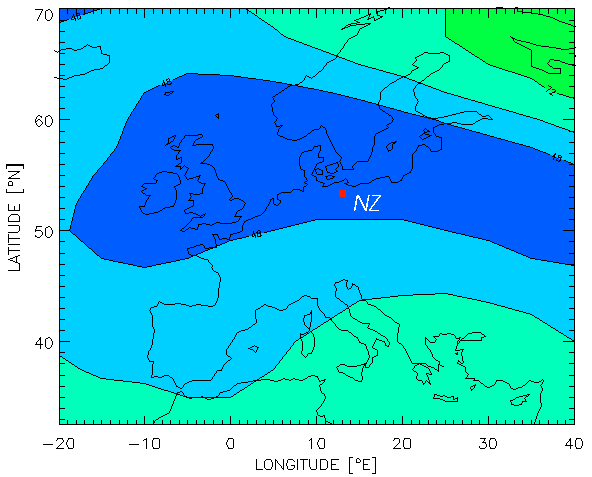
The mid latitude trough on 11 April 1997 at 00:00 UT
Radio signals travelling through the Earth's ionosphere are delayed due to the interaction of the electromagnetic wave field with the plasma in particular with the free electron gas. Since the plasma resonance frequency in the ionosphere is generally below 20 MHz, this interaction reduces with increasing radio frequency (~ 1 / f2). Nevertheless, the effect is still significant in the L- and/or S-band or even higher. The net effect upon radio waves is proportional to the integrated electron density (total electron content - TEC) along the line-of-sight signal path between a satellite to a receiver. So TEC is a key parameter that describes the major impact of the ionized atmosphere on the propagation of radio waves.
The ionosphere itself is a very dynamic region that couples strongly with thermosphere and magnetosphere systems. Although the solar control - visible in diurnal, seasonal and solar cycle variations of TEC - clearly dominates, nonlinear coupling effects lead to a high day-to-day variability in TEC of about 30%.
Due to the dispersive nature of the ionosphere mentioned above, differential code and carrier phases at L1/L2 frequencies can be computed. From these the total electron content TEC may be derived assuming that L1 and L2 signals travel at nearly the same ray paths. It has to be mentioned that the pseudorange measurements provide rather noisy (multipath effect) absolute TEC values (calibration needed) whereas the considerably less noisy carrier phases due to the unknown cycle number provide accurate relative TEC variations.
The algorithm for TEC estimation from GPS measurements used here is described by
Sardon et al.(1994).
Assuming a second-order polynomial approximation for TEC variations over the
observing GPS ground station, both TEC as well as the instrumental satellite-receiver biases are
estimated by a Kalman filter run over 24 hours. So the 30s data of GPS stations of the European
IGS network (table of stations in the bias section) allow
the determination of slant TEC values
along numerous satellite-receiver links over the European area with high time resolution. The slant
TEC data are then mapped to the vertical by applying a mapping function which is based on a
single layer approximation at hsp=400km.
Maps of vertical TEC are generated since 1995 by combining the observed TEC data with a regional TEC model (Neustrelitz TEC Model-NTCM) in such a way that the map provides measured values near measuring points and model values at regions without measured data. This procedure has the advantage that also in case of a low number of measurements physically reasonable TEC data can be provided to a user (for a more detailed description see next section). The NTCM model and the corresponding map generation technique is described elsewhere (eg. Jakowski et al. 1996,1997,1998).
GPS based monitoring of TEC that achieves an accuracy of about 2..3 TECU provides an
outstanding tool for studying large scale processes in the ionosphere. So the horizontal extension of
large scale structures can be detected as it is demonstrated in the figure above where the mid-latitude
trough that has been developed in the coarse of the geomagnetic storm on can be seen.
Near-real-time ionospheric monitoring and the delivery of TEC maps to single frequency GPS
and/or GLONASS users for ionospheric corrections has the potential to enhance accuracy and
integrity of navigation satellite systems.
The ionospheric monitoring technique based on global and regional GPS measurements can
contribute directly to 'Space Weather' monitoring and corresponding predictions.